New Data and Techniques for Transportation Economists
New Data and Techniques for Transportation Economists
Highway link speed data from vehicle GPS probes has become the standard for performance measurement, available free to state DOTs through the National Performance Management Research Data Set (NPMRDS). This data can add value across transportation planning and policy-making. At EBP, we think it extends the potential for informed economic analysis.
For Missouri DOT, EDR Group (now EBP) conducted benefit-cost and economic impact analysis of an Incident Management System (IMS) on the rural sections of I-70 and I-44. To evaluate the impact of MoDOT’s proposed IMS, we needed to understand the pattern and costs of incidents along the rural highways. To do so, we used vehicle speed data from HERE. We queried 5 years of speed records at 15-minute intervals for every link on rural I-70 and I-44: approximately 143 million rows of data in total. That’s a lot of data!
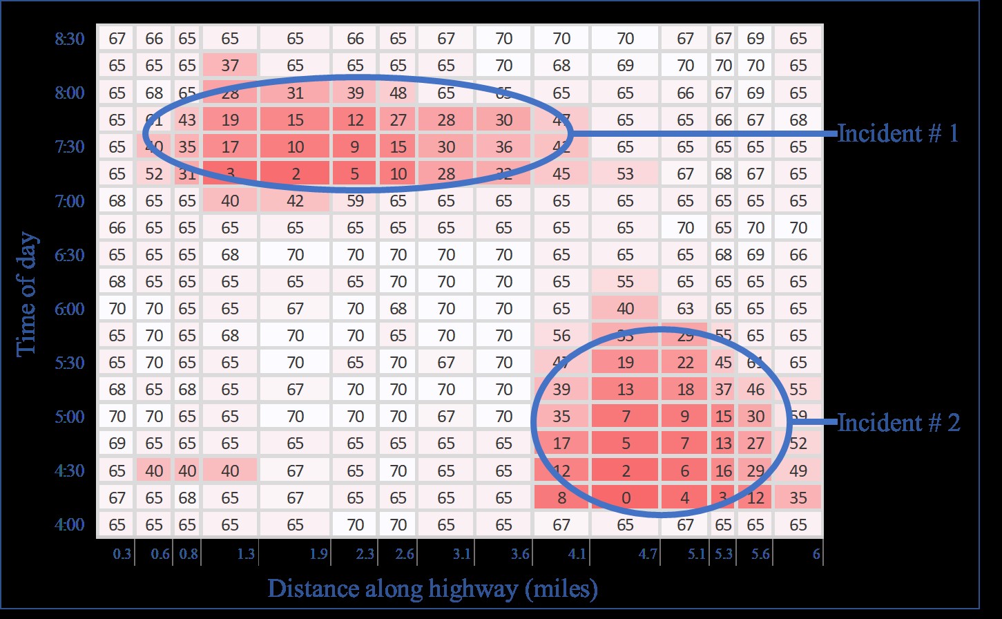
Figure 1 Schematic of incident identification. Using heuristics and a spatial clustering algorithm, we automated this process to identify incidents from 5 years (143 million rows) of speed data
This not-quite-big data requires clever processing techniques. We developed a methodology using heuristics and a spatial clustering algorithm to automatically identify incidents from the data. We evaluated incident durations, the spatial extent of incidents, the distribution of speeds during incidents, and the frequency of incidents occurring at different locations along the highway. Combining this with traffic volume data, we were able to estimate the impacts of incidents in terms of vehicle-hours of delay, by location. This detailed understanding of the “base” case informed reasonable assumptions for how incident durations and speed durations during incidents would change with the implementation of the IMS.
Data sources like GPS probes will continue to evolve, providing information on the movement of passengers, vehicles, and freight. Economic analysis is at its best when it takes advantage of the best information. That means developing techniques to incorporate new data sources as they emerge.
Figure 2 Map of delay caused by incidents, based on analysis of HERE data

